![]()
![]()

This area is called the Kinki region, or the Kidai region. In olden times, kidai indicated “a stretch of land containing paddies and fields under the royal dynasties” mainly around Kyoto. Ancient Japanese dynasties built their capitals along the Yodo River. The streams which irrigated paddies and field of these capitals, all converged to the Yodo River and flowed into Osaka Bay (see map below).
Lake Biwa with particularly large catchment area receives water from approximately 120 rivers, and its outlet is only the Seta River. The Seta River which starts in Shiga Prefecture, changes its name to Uji River upon the border to Kyoto Prefecture and finally becomes Yodo River after merging with Katsura River and Kizu River.
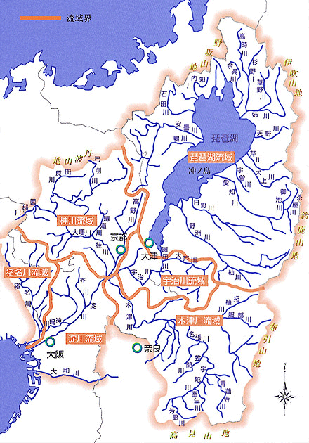
Major Rivers
in the Yodo River System
Rice farming led many people to wealth, and by this wealth the rich were encouraged to engage more in water-use (with projects involving irrigation, drainage and reclamation engineering) for more crops and further wealth. Local clans of ancient times expanded their influences through this cycle of prosperity. After a number of clans battled each other and were screened out into a unified government, the dynasty resulted in the emergence of a capital city. Capitals naturally needed to be built on flat and spacious land. Still more important was that they should be located where river water from stable and abundant water sources was easily available, and droughts and floods seldom occurred. In other words, the capital had to be located in a place with good water-use conditions.
Particularly, in ancient times when only primitive civil engineering techniques were available, natural fertile rice paddies and natural good rivers which were like natural harbors, certainly contributed to the establishment of those regimes in no small way.

Setakara Bridge
Needless to say, the primary factor contributing to this region, kidai (previously mentioned), was Lake Biwa.
It was only from the Meiji era that Japanese society achieved the modern technology of dam construction. However, this area since ancient times or before the dawn of civilization, had the most massive natural dam in Japan which indeed might be mistaken for an ocean at first glance. In addition, it had a gently sloping large river which is rare in Japan and had very little plateau with some volcanic ash zone which is frequently seen along other large rivers: thus, the region had a sweeping expanse of plains and basins which were readily developed into rice paddies.
Surely, no other land could be better suited for the settlement of Yayoi culture--Japan’s ancient culture (before about the third century).
Lake Biwa*
Surface area: 670 km2, Height of water level: 86 m, Maximum depth: 104 m, Water capacity: 27.6 billion tons.
This lake is an enormous reservoir which can serve water for 8.6 million residents of Osaka Prefecture for two days by only the 5 mm difference in depth. During floods, it also plays the role of a gigantic regulating reservoir with the capacity of enormous amounts of water.
A capital, it also needs to be convenient for trade and commerce. Unlike the ocean, lakes have few waves. In olden times, it was far faster and easier to convey goods by water than by land.
The distance from Shiotsu at the north shore of Lake Biwa to the Sea of Japan is only 20 km. Transport by boat and barge to Osaka Bay was also possible. Lakes and rivers took such a role as we might require from the Shinkansen bullet trains in our modern age. Accordingly, this location must have been admired by powerful clans in other regions.
On the other hand, this area had difficult problems.
We have already seen that Lake Biwa played a very important role as a giant regulating reservoir in the Kidai region. A regulating reservoir is the one that temporarily holds rainwater during floods in order to prevent it from pouring directly into rivers.
Please take a look at the map below. You can see how many rivers are flowing into Lake Biwa. And the only outlet is Seta River.
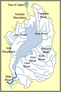
Water System of Lake Biwa
We can easily imagine what would happen due to intense rainfall during the rainy season. The water level of Lake Biwa would go up and submerge the plains in the Kotou (east bank) region. It was not unusual for floods to damage several thousand to ten thousand hectares. Could the Seta River, the sole exit of the lake, be widened? This was probably the historical fervent wish of the people living near Lake Biwa since ancient times till just recently.
However, the exit at Seta was extremely narrowly constrained by Mount Dainichi, which juts out at this point. In the Edo era, inhabitants repeatedly petitioned authorities to improve this situation. Kawamura Zuiken, who was a prominent local figure in terms of his work in flood control, was also engaged in such works, but could not find a fundamental solution.
What about dredging deeper down the Seta River, the sole outlet of the enormous regulating reservoir, Lake Biwa?
As is mentioned paradoxically, there were people in some regions along the Seta River who would be just as or even more worried than the inhabitants along Lake Biwa, if such dredging was done.