Chapter 5
The Niigata Plain Today
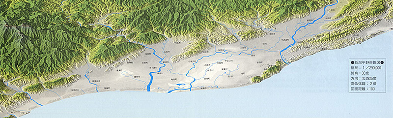
Current Map
The current map shown here is a computer graphics generated by analyzing precise geographical data about latitude, longitude, elevation, etc. and applying multi-layering techniques. In short, it shows a view of the reproduction of the real land without buildings, houses and other structures. We first notice that there is surprisingly little difference between the current terrain and the one in the year-1089 map. Accordingly, it is not surprising to see that the zone of sandy soil on today’s map may all have been part of the ocean in earlier times.
- Rain and snow falling on the extensive areas of the Echigo and Iide Mountains eventually run off through more than 1,000 rivers and flow onto the Niigata Plain.
- These rivers carve deep gorges leading to the estuaries which are drawn on the year-1089 map.
- As a reference, the gradient from Nagaoka to Niigata along Shinano River is as small as 1/4100. Along Kaji River, it is even flatter, ranging between 1/5000 and 1/7000, meaning that water travels several kilometers with just the difference of one meter down.
- It is only now that the rivers are held back by huge embankments. We can easily imagine how they would break loose from their usual paths of old times, wildly twisting and turning about like giant snakes whenever it rained heavily.
- Moreover, the debris carried down by turbulent waters would finally stay piled in the sea from the side of the mountain so that the sea turned into sandy land.
- We would also like to pay attention to the fact that the entire coastline has been raised up like a bank, which corresponds to the islands drawn on the year-1089 map. Apparently, it is not a bank but more like sand dunes that formed along the seaside, measuring 20 to 30 meters in height. They are like a very long belt of hills.
- The scattered zones in the plains, indicated in white, are areas below sea level. (The large white zone in the center is the Kamedagou region, otherwise known as the unmapped lake till pre-World War II times.)
- Namely, we can see that the entire coastline is higher than the inland area. In short, this means that the Niigata Plain is shaped like a long and narrow bowl, otherwise more like a large lake than an ocean.
- Therefore, we can say that over a mere 900 years, historically a short time span, the large shallow lake was filled with debris from nearby mountains and became an enormous tideland which is several times larger than Hachirougata in Akita prefecture.